Four years after massive floods ravaged Kashmir, not many lessons have been learnt. While officials term machine-manicuring of water bodies and funds worth crores as its immediate flood response, the existing situation tells another story. As the official-broker-buyer nexus is now even turning flood sponges aka wetlands into colonies, Kashmir finds itself on frequent flood predicaments.
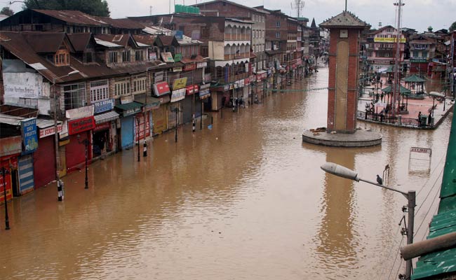
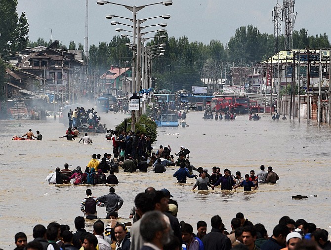
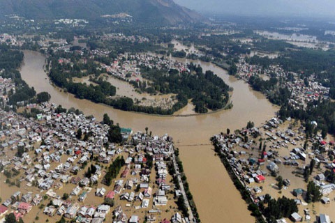
Floods are not new to Kashmir, but when a brimmed Jhelum ran wild in the fall of 2014, it made a muck of 2,61,361 structures, 3,27,000 hectares of agricultural land and 3,96,000 hectares of horticulture land. By the time the river resumed its normal course, Kashmir had suffered over Rs 300 billion loss in the housing sector and Rs 700 billion loss in business sector, thus making it the most disquieting deluge of the century.
After being caught off guard, the dispensation of the day was castigated for playing Nero while Rome was burning.
Post-floods, the deluge of the valley was discussed threadbare in order to prepare a flood action plan. But while much of that protection plan remains an unfinished business even today, Kashmir’s flood past often returns to haunt it, even with a few days of rainfall now.
The Valley might have its own tragic flood history, but it’s the overall response from its official machinery and societal elements now which is making it a freak event.
In his book, Jhelum, The River Through My Backyard (2001), Khalid Bashir Ahmad, a renowned Kashmiri historian writes that the oldest recorded flood dates back to the reign of Raja Sundersen (BC 2082-2041) when the “Khadanyar mountain slipped, due to an earthquake, in the Ollar Nag”.
It had stopped the passage of water inundating the whole valley up to Bejbehara in south Kashmir. For a thousand years, Bashir writes, half of the Kashmir Valley remained submerged.
Bashir notes that flood hit the valley in the summer of 1950, in 1957, in September 1966, May 1968, August 1973, July 1975, August 1976, August 1985, May 1986, June 1987 and Sept 1998.
ALSO READ: The day Jhelum, the poet’s muse, went loose…
In his travel book, The Valley of Kashmir (1895), English writer Sir Walter Roper Lawrence writes that floods have been hitting Kashmir since A.D 879. “In 1841, there was a serious flood, which caused much damage to life and property. The flood equalled to, or surpassed the disaster of 1893,” he writes.
“There was only one meteorological station in Kashmir when the flood occurred at Srinagar and five inches of rain destroyed it. The warning was received by telegraph from Islamabad that a heavy flood was coming down,” Lawrence writes in his book.
While the forecasting systems of the meteorological department are headway, with nothing being done on the ground, it doesn’t help.
Aijaz Rasool, a Hydraulic Expert and advisor to Environment policy group, describes Kashmir as a bowl, the river slope of which is mild up to the Wular Lake. Thereafter, the slope increases till the river flows beyond Uri.
“The longitudinal section beyond Wular is analogous to a spout in the bowl-shaped valley,” Rasool says. “So the flow of water increases in the outflow channel of the river beyond Wular.”

The sedimentation of the river and Wular Lake after a few rainy days results in a flash flood condition “with the bowl getting filled up and spills in the spout less than the inflows. It causes an immediate rise in water levels in the river.”
As soon as the flash flood passes downstream, he says, the outflow takes time to subside.
“This is the reason that from 1960 to 1986 and then from 2010 onwards, the dredging of the river was done in the outflow channel of Jhelum beyond Wular in the reach from Sopore to Baramulla. This was aimed to increase the velocity of flow and induce the quick discharge of water,” the hydraulic expert says.
ALSO READ: Remembering September 2014 Floods in Poetry
Government has flood control and mitigation plans formulated by Irrigation and Flood Control (I&FC) department, he says, which were framed to take care of the anticipated major flood on the basis of flood frequency analysis which had forecasted that a major flood in last 100 years was most probably in the offing from 2010 to 2015.
However, no considerable measures were taken and the valley got inundated in September 2014.
The measures taken after the floods are futile as per Rasool who says that the dredging in Srinagar was an ‘ill-conceived project’ and that most of the work of I&FC that he has examined has been done on unscientific lines.
“In fact,” he says, “I had also asked I&FC not to provide ‘No Objection Certificates’ for fitting any pipeline going through the Bunds. The short-term projects of I&FC that I checked were not up to the mark.”

For instance, he says, the silt removed in the achievement of 17 per cent of envisaged targets of I&FC will be replaced by equivalent silt getting deposited. “This dredging has not helped to address the problem of floods in any way and we’re still at the same state, as we were after 2014 floods.”
Giving an idea of what kind of protection measures would be taken by the older generations, P.N.K Bamzai (1987) in his book Socio-Economic History of Kashmir (1846-1925) writes, “the flood of 1903 had swept away this locality and the Resident, Sir Luis Dane, decided to undertake flood protection measures on a long-term basis. The State Engineer, Mr Field, in collaboration with the Electrical engineer, Major A. De Lotbiniere were detailed to prepare a comprehensive scheme in this respect. After a survey of several months, they submitted their note and chief recommendations.”
According to the book, the engineers had recommended giving a quicker and wider outlet to the flood waters of the Valley, the bed of the river from the Wular lake to Baramulla be deepened and widened. This was to be done by dredgers to be run by electric power which the engineers proposed to generate at Mahora, sixteen miles down.
ALSO READ: 2014 Deluge: I was safe, but there were others to be saved
Interestingly, the Uri powerhouse which eventually supplied electricity to the city, was originally and exclusively meant for dredging operations.
Another important recommendation of the engineers, Bamzai writes, was to widen the spill channel from above Srinagar to a point 15 miles below it towards the west. This, they thought, would carry a huge quantity of flood waters and would definitely help in saving the city from destruction.
“In 1905-06, the machinery required for the hydro-electric generating plant at the Mahora and the dredgers for deepening of the bed of the river at Baramulla were ordered from America. The Mahora powerhouse was completed by the end of 1907. It was the second hydroelectric project then in India, the first one being in Mysore,” writes Bamzai.

Dredging operations, he writes, began in 1908, and by 1912, an area of 6,100 acres was reclaimed from around the Wular Lake. It was allotted to cultivators for paddy cultivation. The official report on dredging dated July 13 1911 mentioned that since the operations began two years earlier, the level of Jhelum was considerably reduced; the velocity of the current between Sopore and Baramulla had been largely increased resulting in a much greater discharge of river. But the maintenance charges of the dredgers and the replacement of their worn out parts was a big drain on the slender resources of the state.
“The dredging operations, though valuable in their own way, were looked down upon by the state as useless expenditure, and in 1917, the dredgers were sold as junk. The result was that the old story of silting up of the river bed in the Wular lake was repeated and when in 1928 there was a flood towards the end of August, the low lying parts of the city of Srinagar which had to then extend to a larger area were inundated and destruction was caused to the standing crops,” writes Bamzai.
Again the state government woke up to take flood protection measures, but instead of having a long-term view of the problem, they started again to build high bunds around the low lying parts of Srinagar—the chief aim being to save the city at the cost of rest of the valley.
As per Bashir’s book, in The Master Plan of 1959, the major part of the work was confined to the improvement of the outfall channel of the Jhelum. “Since the plan could not mitigate the flood hazards in the upstream Srinagar, the Government constituted a six-member committee in 1975 to evaluate, among other things, the work is physically done on the Master Plan and the benefits accrued therefrom, examine and re-appraise the proposals and suggest improvements and modifications,” he writes.
The significant works executed during 1950-60 were the raising and strengthening of embankments, both upstream and downstream from Srinagar, in the reaches more susceptible to breaches and overflow, extension and improvement of Flood Spill Channel to restore it to its original capacity of 17000 cusses, construction of marginal bunds around Nambals and lakes en route and construction, reconditioning and repairs of various sluices and drainage channels flowing into the river, Bashir notes.
“The flood control works done between 1950-75 resulted in reducing the number of breaches that used to occur and to, that extent, helped in the protection of the cultivable land; the improvements to the Flood Spill Channel provided increased protection to the Srinagar city while the construction of sluices and drainage gates reduced the period of submergence of the cultivable land.”
The dredging process would be considered a futile exercise even before the insurgency erupted in Kashmir in late 1980s. However, the threat to life led to the increase in the making of ‘war beneficiaries’ i.e., the brokers who bought and sold land—even wetlands.
That was the period, says Prof. S. A. Ramshoo, Head of the Department of Earth Sciences, Kashmir University, when there was the threat to one’s life and therefore, environment became the least priority in Kashmir.
“From 1980s the dredging was neglected,” he says. “And from 1990s, when the state and non-state actors looted our green gold, it led to a lot of slit in rivers and tributaries, the carrying capacity and drainage capability of which has drastically lowered now.”
ALSO READ: How conversion of Bemina from flood basin to residential area endangered Srinagar
Government alone cannot be blamed for the encroachments of flood channels, the professor says. “As individuals, community and government, we have failed. We are supposed to construct homes as per codes. But what people do is that they bribe a municipality officer and take a huge risk. We’re paying money to put our families at risk. And equally, the terrible thing is that hardly any opinion from an environmentalist is sought in this regard.”
So far, the dredging done is hotchpotch, ad-hoc and unscientific, Dr Ramshoo says. “They did it where it was not required. Science, Technology and Knowledge in Jammu and Kashmir do not influence the decision or policy-making. On the ground, they don’t care at all.”
Substantiating Professor’s point, a land broker says that Pathwaris (brokers) show a part of flood channel with the mainland, fill the basin and grow grass on it, bribe the officials, who then grant permits to construct anything on the land.
“I had started the business in 1985,” the suave-faced broker says. “I don’t do it now but it’s all about money. Also, you tamper with the records and grow grass on the filled land. So even if someone comes for inspection, you are clear on your part.” Otherwise, he says, everyone knows that construction is banned in the flood basin.
One day, he details, a woman Tehsildar asked his Pathwari class to pay her Rs. 50,000 for house construction. “We had to arrange it,” he says. “Else, she would not have been flexible.”
It’s a clear nexus at play. The brokers introduce the potential buyers to the officials who take money form the buyer.
“We bought the land in a flood channel,” says a buyer from Mehjoor Nagar. “We had to get the permissions which we managed to get from the Tehsildar. We had to pay some money to him. He then managed everything from land to building permits. Within a month, it was done.”
Amid this brazen conversion of flood channels into housing colonies, an extensive human interference in Wular Lake has escalated the flood threat.
Besides being one of the largest freshwater lakes in Asia, Wular in Bandipora is also the largest flood basin of Kashmir.
Designated as a wetland of international importance under the Ramsar Convention in 1990, Wular lake is home to coniferous forests and alpine pastures which adds uniqueness to the biodiversity of the wetland area.

Wular Lake.
Before the 2014 floods, the widespread encroachment of the lake turned its marshes into agriculture land and gradually settlements and plantations emerged.
And after the floods, de-silting has become a dire need in all swelled water bodies including Wular. This increased silt deposition and encroachment has reduced the water retention capacity of the water bodies and wetland acting as sponges in times of excess water.
Humayun Rashid and Gowher Naseem of Srinagar’s Directorate of Environment, Ecology and Remote Sensing (DEERS) have concluded in their study that more than 50% of water bodies in Srinagar and its suburbs have been lost during the past century and that’s the reason the city is now facing frequent flood scare, even if it rains continuously for only two to three days.
During the last decade, the study notes, areas which having no flood history are getting inundated and this is because there is hardly any wetland left to hold the excess water and act as sponges. “During 1911-2008, the overall water spread and marsh areas shrunk by over half, reducing one-fifth of the area’s water storage capacity. This change in the natural course of water bodies and wetlands has increased the risk of floods.”
Post-2014 floods, the failure to remove the suspended silt across drainage networks post has also increased chances of overflow in the low-lying areas of Srinagar.
“The government in the last four years has released some funds in crores for dredging of water bodies and strengthening the weak points,” says Er. M.M Shahnawaz, Chief Engineer I&FC.
“In Srinagar, we have 2 stretches from Shivpora to Panzinara, Noorbagh. Government has also spent Rs 9 lakh 15 thousand crores for dregding in Sopore and Baramulla districts.” Also, Rs 142 crores had been released by government last year for widening of Jhelum, he says.

But despite spending crores, the flood concerns surface with a day or two of heavy rains.
“See, all this dredging process of rivers and streams is ill-conceived and meant to befool the innocent people,” says prominent Civil Engineer, Iftikar Drabu. “Government has no plans to address the flood problems.”
Dredging, he says, is always started from the downstream side towards upstream. It reduces the risk of flood to the downstream areas.
“Dredging needs to be undertaken downstream of Wular lake since that will improve the discharge capacity of that stretch of the river and thus enable quicker draining of the Wular,” he says. “This can allow us to lower the water level in Wular which will result in increase of the head difference on the upstream side thereby vastly increasing the carrying capacity of Jhelum.”
Even if Jhelum is fully dredged, Drabu says, it cannot prevent floods. The carrying capacity of Jhelum is only 35,000 cusecs of water while during the times of 2014 floods, 120000 cusecs of water flew in it.
And therefore, he says, dredging is not going to work. “We need solutions which will ensure complete protection, are not very cost intensive, are one time and non-recurring, do not require long gestation periods.”
But given how flood measures are shaping up in the valley, Kashmiri saying—Yupis Kya Kare Shup (You cannot control floods, Yup, with a dustpan)—perhaps best explains the current flood tackling ability of the valley.
Afshan Rashid, Fajar Shora and Sheikh Saqib contributed to this story.
Like this story? Producing quality journalism costs. Make a Donation & help keep our work going.